NOTE: This Page Shows Contents from Stansbury Mine Geologist Technical Report by James F. Kohler, Professional Geologist.
CLICK HERE TO READ FULL REPORT

Summary

The Stansbury Island Oolitic Sand property contains deposits of oolitic sand deposited in along the shores of the Great Salt Lake that ADNA, LLC, dba Volcanic Safeguard Holdings believes are suitable for producing and marketed as a soil amendment. The lands included within the claim private lands, and the rights to develop the deposit would be acquired through a lease from the property owner.

Introduction

Utah Geosystems, LLC has been commissioned by ADANA, LLC, dba Volcanic Safeguard Holdings (Client) to provide a geologic review of a deposit of oolitic sand on the north end of Stansbury Island the client intends to lease production of material suitable for use as a soil amendment. The purpose of this report is to summarize the initial review of this deposit and provide recommendations for further evaluation of the property.

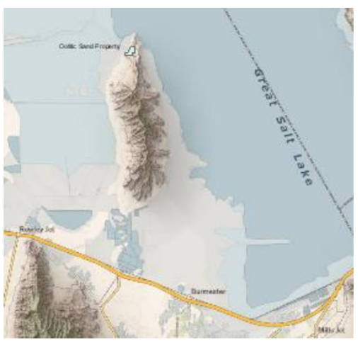
Property Description and Location

The Oolitic Sand Property considered in this report is located in Tooele County at the north end of Stansbury Island (figure 1). The is identified as Tooele County Tax Parcel No. 04-014-0-0001. The parcel consists of 100.59 acres in parts of the SE 1⁄4 of Section 9 and the SW 1⁄4 of Section 10, T. 2 N., R. 6 W., SLM.
FIGURE 1: LOCATION OF THE OOLITIC SAND PROPERTY ON STANSBURY ISLAND
FIGURE 2: AERIAL VIEW OF OOLITIC SAND PROPERTY PARCEL 04-014-0-0001

Land Status

The property is private land. It is expected that rights to develop the oolitic sand deposits would be obtained through a lease from the property owner.

Accessibility, Topography, and Vegetation

The property is accessed by an improved gravel road that goes north from Interstate Highway 80 along the west side of Stansbury Island. The area containing the targeted deposit is adjacent to the mudflats along the shore of the Great Salt Lake and the north end of Stansbury Island. The oolite deposits are found in a series of beach dunes that are parallel to the shoreline. The dunes reach a height of 15 to 20 feet above the mudflats at the Great Salt Lake margin. As is shown on figure 3, the elevation of the area underlain by the oolite deposits generally is between 4220 and 4240 feet. The oolite area is covered in part by junipers and other scrub vegetation.
FIGURE 3: TOPOGRAPHY OF THE OOLITIC SAND PROPERTY

Geological Setting and Mineralization

The surface geology of the property is shown in figure 4 (Chapusa, 1969). The oolitic sand deposits (Qlts) occupy the northwest portion of the property adjacent to the lakebed mud flats. When the Great Salt Lake reaches its historical average level of 4,200 feet, the oolitic sand deposits would be a little over 20 feet above the water level.
FIGURE 4: GEOLOGIC MAP OF THE OOLITIC SAND PROPERTY (CHAPUSA, 1969)
According to the Utah Geological Survey, the oolitic sand is an unusual sediment that is found in and around the Great Salt Lake. An oolite is a well-rounded grain particle, formed by the concentric precipitation of calcite or aragonite around a nucleus. For the oolitic sands around the Great Salt Lake, the nucleus is generally thought to be either a brine shrimp fecal pellet or a mineral fragment. Oolites form in supersaturated, shallow, wave-agitated waters. The oolitic sands are moved by wave action or wind to accumulate in dunes on the margin of the lake. A picture of the unusual grains of oolitic sand is shown in figure 5, which shows the well-rounded nature of the individual sand grains.
FIGURE 5: OOLITIC SAND FROM THE GREAT SALT LAKE (FROM UTAH GEOLOGICAL SURVEY)
A manure/compost analyses of the oolitic sand taken by the client report the chemical composition of the oolitic sand as shown in figure 6. This test is used to measure the organic matter and nutrients that can be added to soil by a compost product. The applicability of this test for establishing the suitability of this material for use as a soil amendment is beyond the scope of this report. The analyses provided for this report compared with analyses reported by Azomite Mineral Products for a product being marketed as a soil amendment is shown below in Table 1.

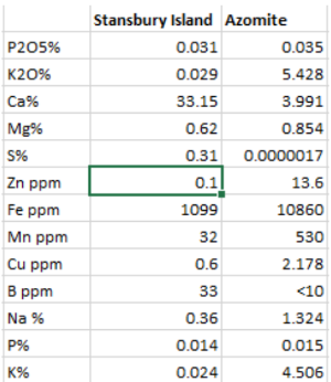
TABLE 1: COMPARISON OF OOLITIC SAND WITH AZOMITE

As would be expected from the origin of the oolitic sand in the Great Salt Lake, the oolitic sand has a higher calcium, boron, and sulfur content.
FIGURE 6: LABORATORY ANALYSIS OF OOLITIC SAND DEPOSIT

Mineral Resource Estimates

As is shown on figure 4, the lowlands in the northwestern edge of the property are underlain by deposits consisting largely of oolitic sand. This was confirmed by the field visit on May 3, 2023. For an initial resource estimate for the oolitic sand available within the property, the following parameters were used:
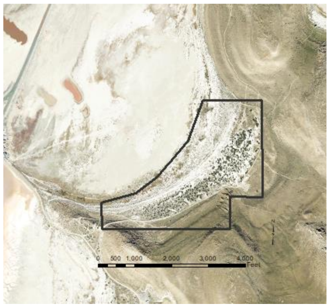
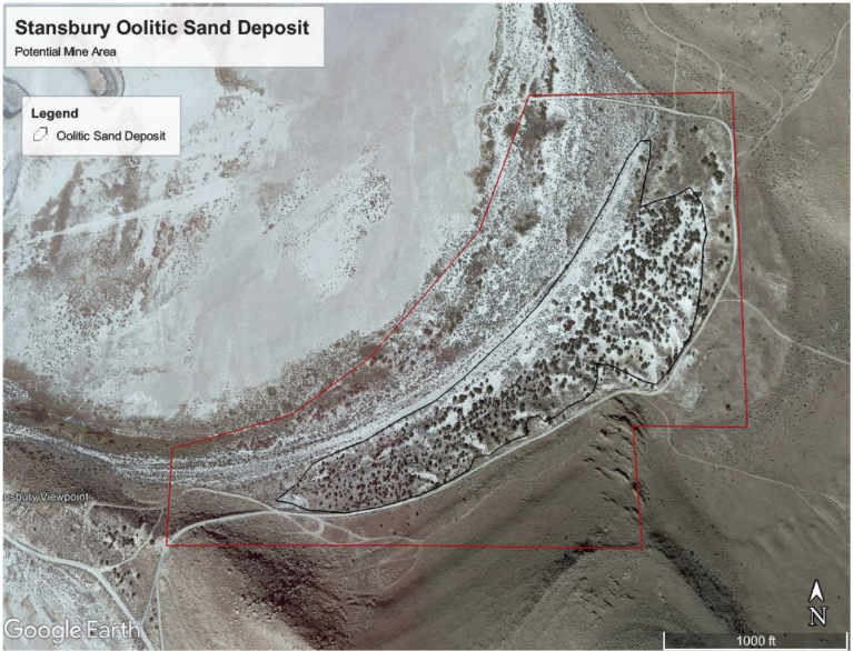
• The potential mine area was identified by using the image of the north end of Stansbury Island and outlining the main portion of the oolitic sand deposit as is shown on figure 7. limited on the west by the material site right-of-way, on the south by the highway and fiber optic line right-of- way, and on the east by the ephemeral drainage containing alluvial deposits.
• The average thickness of the deposit was assumed to be 10 feet thick.
• The unit weight of the material was assumed to be a conservative 95 lbs per ft.3
The potential mine area covers 40.9 acres. The initial resource estimate is summarized as follows: Unit Weight 95 lbs. per ft.3 = 2,069 tons per acre-ft. 36.3 acres x 10 ft. = 363 acre-ft. 363 acre ft. x 2,069 tons per acre-ft = 751,047 tons A conservative estimate of the available resources available within the boundary oolitic sand deposit at the north end of Stansbury Island would be 750,000 tons. Additional resources may be added if further exploration demonstrates that the average thickness of the deposit is shown to be greater than the conservative 10 feet used in this report. In addition, other oolitic sand deposits are found on additional lands available for lease which would add significant additional resources for development.

Interpretation and Conclusions

The tract of land reviewed in this report contains a deposit of oolitic sand that has accumulated in beach dunes on the north end of Stansbury Island. The resource estimate of 750,000 tons is conservative based on an assumed average thickness of 10 ft. for the deposit. If exploration by drilling or trenching would confirm that the deposit has a thickness greater that 10 feet, the resource estimate is likely to increase.

Recommendations

To refine this preliminary estimate of the resources/reserves, it is recommended that a series of auger holes be drilled over the area proposed for development with a grid spacing of about 500 ft. to confirm the thickness of the targeted material. Testing of the material as a soil amendment to show whether plant growth is enhanced by adding the oolitic sand to soil will be necessary to show the marketability of this material for this use.

References

Chapusa, Frank W. P., 1969, “Geology and structure of Stansbury Island”, Thesis University of Utah,
College of Mines & Earth Sciences, https://collections.lib.utah.edu/ark:/87278/s6xd1ggg.

Lawrence, Robert, 2018, “The Mysterious Origin of Oolitic Sand”, Hakai Magazine – Coastal Science and
Societies,
https://hakaimagazine.com/news/the-mysterious-origin-of-oolitic-sand/.

Palmer, Dennis E., 1970, “Geology of Stansbury Island, Toole County, Utah”, Brigham Young University
Geology Studies, Volume 17, Part 2 – December 1970.

Wilkerson, Christine M., , “The Rockhounder: Oolitic Sand on Stansbury Island”, Utah Geological Survey,
https://geology.utah.gov/popular/rocks-minerals/rock-mineral-collecting-sites/oolitic-sand/.