CLICK HERE TO READ FULL REPORT
Summary
The South Bend #1 and #2 Mine Claims contains deposits of sediments deposited in Lake Bonneville that ADNA, LLC, dba Volcanic Safeguard Holdings believes are suitable for producing and marketed as a soil amendment. The lands included within the claim are public lands administered by the Bureau of Land Management and are open for mining location. The claimed lands contain a number of pre-existing rights-of-way which will likely restrict the development of the areas of the claim covered by these rightsof-way. Additional field work and sampling will be necessary before an initial estimate of available resources can be finalized
Introduction
Utah Geosystems, LLC has been commissioned by ADNA, LLC, dba Volcanic Safeguard Holdings (Client) to provide a geologic review of a mining claims known as the South Bend #1 Mine Claim and South Bend #2 Mine Claim held by the Client for production of material suitable for use as a soil amendment. The purpose of this report is to summarize the initial review of this claim and provide recommendations for further evaluation of the property.
Property Description and Location
The South Bend #1 and #2 Mine Claims are located in Millard County, Utah, about 40 miles southwest of Delta, Utah (figure 1).

The legal description for the claims is as follows:
South Bend #1 Mine Claim
T. 20 S., R. 12 W., SLM,
Section 18, SW¼SE¼.
Section 19, NW¼NE ¼, and NE¼NW ¼;
Containing 120 acres, more or less.
South Bend #2 Mine Claim
T. 20 S., R. 12 W., SLM,
Section 18, N½SE¼, and SE¼SE¼
Containing 120 acres more or less.
The claims were originally placer claims that were filed on December 26, 2022. For failure to file the required information for the annual maintenance fees with the BLM, these claims were closed by BLM. The claims were relocated on November 5, 2023, and filed with the BLM on December 8, 2023. The South Bend #1 Mine claim was assigned serial number UT106340679 and the South Bend #2 Mine claim was assigned serial number UT106340680.
Land Status

The claims are located on federal public land managed by the Fillmore Field Office of the United States Bureau of Land Management (BLM). As is shown on the master title plat for T. 20 S., R. 12 W., SLM (figure 2), there are a number of prior rights identified within the boundary of the claims. The southeast portion of the claims is bisected by a right-of-way U-03842 which was issued in 1950 for the highway. To the north of the highway, there is a fiber-optic cable right-of-way U-78850 that was issued in 2001 and renewed in 2011, and another right-of-way U-080667 for fiber optic cable that was issued in 2003 and renewed in 2014.
Accessibility, Topography, and Vegetation
Figure 3 shows the topography in the vicinity of the South Bend Mine #1 and #2 claims. As is shown on figure 3, the area of the mining claims generally exhibits low relief with the lands sloping gently to the southeast and elevations range from 4,780 feet in the west to slightly less than 4,650 feet to the southeast where the claim intersects an ephemeral drainage. In the northwestern portion of South Bend #2 Mine Claim, there is a hill consisting of the Ordovician-Cambrian Notch Peak formation which rises to an elevation of almost 4900 feet.
The claim is easily accessed from U.S. Highway 50 which crosses the claim from northeast to southwest and a gravel county road that goes through the claims north of the highway. The surface has a sparse vegetative cover which is typical of the shrub steppe of the Sevier Desert (figure 3). Published information on the vegetation found in the area of the claim reports that the common shrubs include winterfat (Krasheninnikovia lanata and Atriplex canescens in low abundance) , Ephedra nevadensis, and Broom snakeweed (Gutierrezia sarothrae). The area is not quite a salt desert. Sporobolus cryptandrus, Oryzopsis hymenoides, and Aristida purpurea are the common grasses. Halogeton glomeratus and Erodium cicutarium are the common herbs, which along with an abundance of Sporobolus suggest a long history of physical disturbance (Lavin, 2015).
Geological Setting and Mineralization

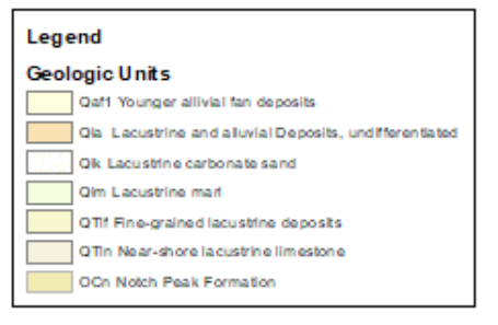
The surface geology of the claim area is shown in figure 4 (Hintze and Davis, 2002). The southeast portion of the claims is underlain by lacustrine and alluvial deposits (Qla) that were deposited in and adjacent to Lake Bonneville during the Holocene and Late Pleistocene periods. Most of the remainder of the claim is mapped as lacustrine carbonate sand (Qlk) that is also late Pleistocene in age. Between these two units, there are scattered exposures of lacustrine marl (Qlm). During the field visit to the property, numerous shell fragments were noted along the material exposed adjacent to the county road. During the field visit of the property on June 19, two shallow auger holes were drilled and samples taken of the targeted material as is shown on figure 6.

Mineral Resource Estimates
The surface of the claim seems to be underlain by sediments deposited in Lake Bonneville that the client believes are suitable to be used and marketed as a soil amendment. The client indicated that their interest was in the “white” material which show up on the aerial images of the area (figure 6). The two auger holes drilled in this material was two to four feet thick where sampled and was underlain by a layer of coarse sand, pebbles and gravel. The drill hole logs for these two holes are shown in Appendix 1.

A sample of the material taken in March by the client was analyzed and the results are summarized in Table 1.
TABLE 1: COMPOST/MANURE ANALYSIS OF SOUTH BEND MINE CLAIM SAMPLE
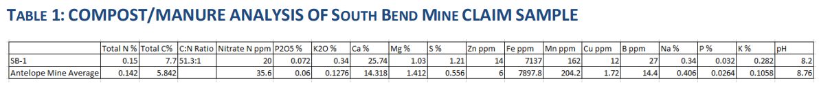
This analysis is based on a sample taken from the surface by the client. No analyses are available from the two auger holes drilled on the property. The client also has identified additional potential soil amendment material on a mining claim known as the Antelope Mine claim which is almost 15 miles northeast of the South Bend #1 and #2 claims adjacent to US 50. As is shown on table 1, the South Bend material exhibits higher calcium and lower sulfur levels which suggests that the material is primarily calcium carbonate. The additional elements analyzed for the South Bend sample are generally less than the average of the Antelope Mine samples. An initial estimate was made for the targeted material on the claims by using the following assumptions:
- The resource area was outlined using the outcrop of the “white” material identified by the client on the Google Earth image of the area shown on figure 6 and extending the area approximately 500 ft. from the outcrop.
- The unit weight of the material was assumed to be 95 pounds per ft^3.
- The average thickness was assumed to be 3 ft., based on the two auger holes.
The northeast resource area shown on figure 6 covers 37.9 acres and the southwest area covers 17.2 acres for a combined resource area of 55.1 acres. The initial resource estimate is summarized as
follows:
- 55.1 acres x 3 ft. = 165.3 acre-feet,
- 165.3 acre-ft. x 2,069 tons per acre-ft. = 342,005.7 tons.
The initial resource estimate suggests that the property could contain 340,000 tons of the targeted material.
Interpretation and Conclusions
Much of the surface of the claims appears to contain sediments the client has targeted for use as a soil amendment. The suitability of this material for this purpose should require additional sampling to confirm the existence and extent of the targeted material away from the outcrop. In addition, the material will need to be analyzed to show that it is suitable for the intended use and identify the unique characteristics of the material that will enable the deposit to not be considered “common variety” and be developed under the provisions of the mining law on a mining claim. This determination will need to be made by BLM before a plan of operation can be approved to allow the deposit to be mined. If BLM determines that the deposit is “common variety”, development rights to the deposit can be obtained through a mineral material sale.
Recommendations
To characterize the nature of the deposit (common or uncommon) and develop an estimate of the resources/reserves, it is recommended that a series of auger holes be drilled over the area proposed for development with a grid spacing of about 500 ft. to confirm the thickness of the targeted material. Representative samples from these auger holes should be analyzed to confirm the suitability of the material for use as a soil amendment.
References
Hintze, L. F., Davis, F. D., 2002, Geologic map of the Tule Valley 30′ x 60′ quadrangle and parts of the Ely, Fish Springs and Kern Mountains 30′ x 60′ quadrangles, northwest Millard County, Utah: Utah Geological Survey Map 186.
Kohler, J.F., 2023, Technical Report, Initial Resource Estimate Antelope Mining Claim Soil Amendments Project Millard County, Utah, Confidential Report prepared for ADANA, LLC, dba Volcanic Safeguard Holdings.
Lavin, M., 2015, Shrub steppe, Sevier Desert (Sevier Lake in background), UT:
http://www.commons.wikimedia.org.