CLICK HERE TO READ FULL REPORT
Summary
The Antelope Mining Claim contains deposits of sediments deposited in Lake Bonneville the ADANA, LLC, dba Volcanic Safeguard Holdings believes are suitable for producing and marketing as a soil amendment. The lands included within the claim are public lands administered by the Bureau of Land Management and are open for mining location. The claimed lands contain a number of pre-existing rights-of-way which will likely restrict the development of the areas of the claim covered by these rights-of-way. An initial review of the property as described in this report suggests that the potential resource that could be developed is on the order of 400,000 tons. Additional resources could be available to the north and east of the identified mine area and south of the highway.
Introduction
Utah Geosystems, LLC has been commissioned by ADANA, LLC, dba Volcanic Safeguard Holdings (Client)
to provide a geologic review of a mining claim known as the Antelope Mine Placer Claim held by the
Client for production of material suitable for use as a soil amendment. The purpose of this report is to
summarize the initial review of this claim and provide recommendations for further evaluation of the
property.
Property Description and Location
The Antelope Mine Placer Claim is located in Millard County, Utah, about 25 miles southwest of Delta, Utah (figure 1). The legal description for the claim is as follows:
T. 19 S., R. 10 W., SLM,
section 7, lot 5, NW ¼ NE ¼, and E ½ NW ¼.
Containing 160 acres, more or less.

Land Status
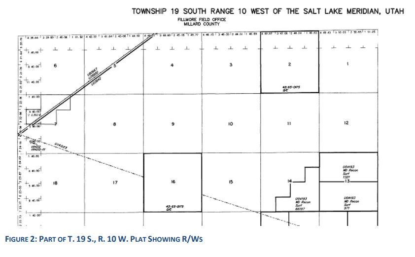
The claim is located on federal public land managed by the Fillmore Field Office of the United StatesBureau of Land Management (BLM). As is shown on the master title plat for T. 19 S., R. 10 W., SLM(figure 2), there are a number of prior rights identified within the boundary of the claim. The claim isbisected by a right-of-way U-03842 which was issued in 1950 for the highway, a right-of-way U-78850for fiber optic cable which was issued in 2001 and renewed in 2011, and a right-of-way for fiber opticcable which was issued in 2003 and renewed in 2014. In addition, the entire claim is included withinright-of-way U-80712 which was issued in 2006 for a Telescope Ray Cosmic Ray Project. The portion ofthe claim in lot 5 (SW ¼ NW ¼ of section 7) is covered by a material site right-of-way U-03924 which wasissued in 1951 for construction materials used to construct the highway.
Accessibility, Topography, and Vegetation
As is shown on figure 3, the area of the mining claim exhibits low relief with the lands sloping gently to the southeast. Elevations range from 4,730 feet in the west to slightly less than 4,680 feet to the east where the claim intersects an ephemeral drainage. The claim is easily accessed from U.S. Highway 50which crosses the claim from northeast to southwest.

The surface has a sparse vegetative cover which is typical of the shrub steppe of the Sevier Desert (figure 3). Published information on the vegetation found in the area of the claim reports that the common shrubs include winterfat (Krasheninnikovia lanata and Atriplex canescens in low abundance) , Ephedra nevadensis, and Broom snakeweed (Gutierrezia sarothrae). The area is not quite a salt desert. However, Sporobolus cryptandrus, Oryzopsis hymenoides, and Aristida purpurea are the common grasses and halogeton glomeratus and Erodium cicutarium are the common herbs, which along with an abundance of Sporobolus suggest a long history of physical disturbance (Lavin, 2015).
Geological Setting and Mineralization
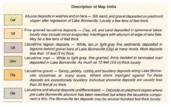
The surface geology of the claim area is shown in figure 4 (Hintze and Davis, 1992). The southwest portion of the claim is mapped as a unit of lacustrine gravel (Qlg) which is described as thin, sandy, pebbly, cobbly and boulder deposits which were deposited along the shoreline of Lake Bonneville. The Utah Department of Transportation investigated the borrow pit in the southwest portion of the claim (Pit Number 14089) and reported that the material contained 94.2% gravel, 5.0% sand and 0.8% silt and clay (Hintze and Davis 1992).

Reportedly, abundant gravel resources are present north and south of this pit. In a later published map that included this area, the same unit was mapped as a fine-grained lacustrine deposit, Pleistocene and Pliocene (Hintze and Davis, 2002). However, based on the field investigation, the earlier map the earlier map appears to represent the conditions on the ground. The bottom of the borrow pit is a consolidated sandstone consisting of medium-size well-rounded sand with a calcium carbonate cement. The area of the claim adjacent to the highway is mapped as fine-grain lacustrine deposits that were deposited in ephemeral lakes. The remainder of the claim is mapped as undifferentiated lacustrine and alluvial deposits with the area in the northeast part of the claim showing alluvial deposits along the ephemeral drainage. Some of the surface of the claim is covered by a thin, pebble and gravel desert pavement that appeared to have a thickness of 1 to 2 inches. During the field visit, the client expressed an interest in a light-colored sandy, silty clay layer that is found at or near the surface over the area mapped as the fine-grained lacustrine deposits.

As part of the field investigation, 5 holes were drilled with an Iwan type soil auger to a depth of 4 to 6 feet. The description of these holes is found in Appendix I. The targeted sandy/silty clay deposit was found to be 4 to 6 feet thick in these drill holes. Samples of the deposit from the auger holes were taken by the client and analyzed by Stukenholtz Laboratory in Twin Falls, Idaho using the soil test known as a manure and compost analysis. The results of the analyses are summarized below in Table 1.
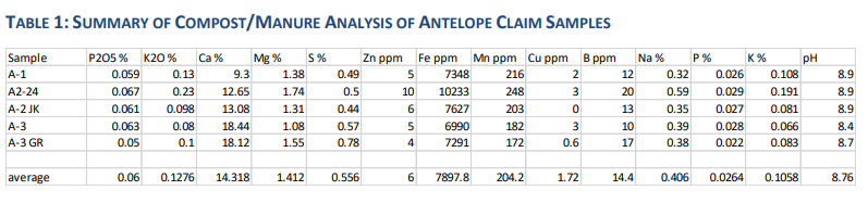
The analyses are contained in Appendix 2. As is shown on Table 1, the targeted deposit is moderately alkaline (pH 8.7) and would be considered calcareous based on the reported 14% calcium in the samples. In order to assess the suitability of this material for use as a soil amendment, the average analyses shown in Table 1 were compared with published analyses for a soil amendment product called Azomite which is presently being marketed by Azomite Mineral Products, Inc. (Azomite International, 2023). The results are summarized in Table 2.

The Antelope Mine samples appear to have a higher content of P2O5, Ca, Mg, and S. The significantly higher content of Ca and S reflect the potential gypsum in the samples which would be expected due to the lacustrine origin of the material.
Mineral Resource Estimates
The surface of the claim seems to be underlain by sediments deposited in Lake Bonneville that the client believes are suitable to be used and marketed as a soil amendment. Four auger holes were drilled along the central part and north of the claim, and the target sandy clay layer was found to be about 5 ft. thick and is underlain by a very fine-grained sand layer. For an initial resource estimate for the potential soil amendment product within the claims, the following parameters were used:
• The average thickness of the deposit was assumed to be 5 feet thick.
• The unit weight of the material was assumed to be a conservative 95 lbs per ft.3
• The potential mine area used for resource estimate is shown on figure 5.
The potential mine area was limited on the west by the material site right-of-way, on the south by the
highway and fiber optic line right-of-way, and on the east by the ephemeral drainage containing alluvial
deposits

The potential mine area covers 40.9 acres. The initial resource estimate is summarized as follows:
• Unit Weight 95 lbs. per ft.3 = 2,069 tons per acre-ft.
• 40.9 acres x 5 ft. = 204.5 acre-ft.
• 204.5 acre ft. x 2,069 tons per acre-ft = 423,110.5 tons.
A conservative estimate of the available resources available within the boundary of the Antelope Mining Claim would be 400,000 tons.
Interpretation and Conclusions
Much of the surface of the claims appears to contain sedimentary deposits the client has targeted for use as a soil amendment. The suitability of this material for this purpose will require testing of the material to verify that plant growth can be enhanced by addition of this material to certain soils. Demonstrating that the chemical composition of this material has a beneficial impact on plant growth will be a step towards identifying the unique characteristics of the material that will enable the deposit to not be considered “common variety” and be developed under the provisions of the mining law on a mining claim. This determination that the material is not “common variety” will need to be made by BLM before a plan of operation can be approved to allow the deposit to be mined as a locatable mineral. The Department of Interior Board of Land Appeals determined that a material used as a soil amendment can be determined locatable if it is a chemical amendment to improve soils (IBLA, 1973). If the targeted sediments If BLM determines that the deposit is “common variety”, development rights to the deposit can be obtained through a mineral material sale.
Recommendations
Testing to demonstrate that adding the material to enhance plant growth will provide evidence to support the marketability of the product which will be necessary to characterize the deposit as a reserve. To better define an estimate of the resources/reserves, it is recommended that a series of auger holes be drilled over the area proposed for development with a grid spacing of about 500 ft., to confirm the thickness of the targeted material. Representative samples from these auger holes should be analyzed to confirm the suitability of the material for use as a soil amendment.
References
Azomite International, 2023, Azomite Mineral Products, Inc. Certificate of Typical Analysis:
https://azomiteinternational.com/resources/coa.pdf
Hintze, L. F, Davis, F. D., 1992, Geologic map of the Long Ridge quadrangle, Millard County, Utah: Utah Geological Survey Map 141.
Hintze, L. F., Davis, F. D., 2002, Geologic map of the Tule Valley 30′ x 60′ quadrangle and parts of the Ely, Fish Springs and Kern Mountains 30′ x 60′ quadrangles, northwest Millard County, Utah: Utah Geological Survey Map 186.
IBLA, 1973, 13IBLA256 (1973), US v Bunkowski, (erratum) aff’d, No. 76-182 (D. Nev. Nov. 27, 1978) aff’d, No. 76-182 (D. Nev. Nov. 27, 1978)
Lavin, M., 2015, Shrub steppe, Sevier Desert (Sevier Lake in background), UT:
http://www.commons.wikimedia.org.
Oviatt, Charles G., 1989, Quaternary Geology of a Part of the Sevier Desert, Utah: Utah Geological and Mineral Survey Special Studies 70.